The Oodnadatta Track and coddiwompling through South Australia
- jmsrtldg
- Jan 25
- 21 min read

Following two months of rehabilitation after my knee operation, staying at my long-suffering friends' (Henri and Kate Nord-Thomson) place on Raymond Island, I had a final session with my physiotherapist, a couple of decidedly lackadaisical orthopaedic specialist follow-ups and a final appointment with my GP. Apart from some residual swelling around the knee, all was good to go.
So having purchased a special South Australia Parks Pass to enable me to cross the Simpson Desert (valid for 12 months....the relevance of which will become evident), I started out in early October to tackle the Oodnadatta Track (an off-road 'rite of passage' in Oz), visit Coober Pedy (the Opal Capital of Australia) and then cross the Simpson Desert from West to East via the French and QAA Lines (exploration tracks) from Mount Dare in SA to Birdsville in QLD. At the time I had not planned much beyond this point, but would still have a month or so of touring before the Christmas holiday season began in earnest.
I had explored the possibility of obtaining a special Simpson Desert Recovery insurance package offered by the Birdsville Hotel, who had a specialised recovery truck that could deploy from Birdsville, recover vehicles onto a tray and return to Birdsville. While not cheap ($500), it would provide peace of mind, noting the amount already invested in my set-up and that alternative recovery options could cost many thousands of dollars due to the remoteness of the area. I was confident that, despite my height measurement exceeding their stated parameters (3.1m vice 3.0m), I was within limits for both weight and length. Having received an initial response saying that they had insured similar motorhome set-ups, my initial confidence was knocked back as they formally responded to say that they were worried about top weight in the soft sand conditions prevalent so late in the season (The Simpson Desert tracks are closed from 1 Dec to 15 Mar due to extreme temperatures)....but they would cover me at the start of the 2026 season and would still consider recovering me if I did get into strife during the planned October 2025 crossing!
So, much to ponder as I continued along my planned track for the time being. My first stop was in a remote place called Powelltown (Pop: @214) on the E side of Melbourne - mainly chosen because it was almost a Free Camp ($5 donation) and because it was still the final week of school holidays in Victoria (and anything close to Melbourne itself was either exorbitantly expensive or already booked out!). The weather enroute from Raymond Island was damp, grey and exceedingly windy, so no photos....


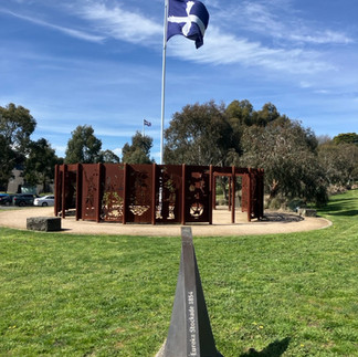

Dark Horse Cafe / Eureka Stockade Monument, Ballarat / Taylors Lake, Horsham
My next destination was Ballarat and environs. I stopped at the Dark Horse Cafe in the middle of seemingly nowhere, but it proved a delightful, sunny spot to enjoy a very good coffee and devour the largest vanilla slice I have ever seen! While passing through Ballarat I visited the Eureka Stockade (the site of a famous rebellion by the gold miners against repressive mining licensing regulations and law enforcement that was savagely put down by government troops in 1854). 276 soldiers and police marched on the hastily-erected wooden stockade to confront @ only 120 people (as the miners had not been expecting an attack on a Sunday!). It was over within 20 minutes, but the death toll was estimated to be as high as 60 (only 6 of the attacking force died). I then camped overnight in a very well-appointed (managed by the Lions) park in Haddon @ 20km SW of Ballarat, followed by a Free Camp at Taylors Lake, near Horsham, as I continued westwards towards SA.
I stopped at a quarantine bin site in aptly-named Bordertown, just inside SA. Here I had to divest myself of all fruit and vegetables or face a stiff penalty...so I duly binned $30-worth of supermarket-purchased products bought in Victoria, to then replace them with exactly the same products purchased from exactly the same supermarket chain 50km away in South Australia! What a load of bs/codswallop! Australia would be a far wealthier nation (...and a far simpler and easier place to live) if it got rid of the mostly nonsensical interstate regulations that do little but unnecessarily duplicate state government administrations (including the over-abundance of highly-paid state and federal politicians) and massively complicate things that should more logically be nationally/federally-controlled (such as vehicle registration, regulation and licensing, for example!).


Lake Bonney Riverland, Barmera
Anyhoo (rant over!), I camped overnight in a dedicated free RV Park in Pinnaroo, which was not busy and within walking distance of all the 'necessaries' (like pub, grocery store and toilets!). I pushed on northwestward to an attractive town called Barmera where I had booked an enormous site in their local park for the princely sum of $7.50 - there was only one other caravan there! Again, the RV park was well-situated and next to a small freshwater lake, Lake Bonney Riverland.


Bon Accord Hotel, Burra / Open Cut Mine, Burra
From Adelaide to the North is a massive viticultural region of SA (as was the Margaret River region of southwest WA that I drove through the previous November!) - I seemed to drive hundreds of kilometres through endless well-manicured and lush vineyards as I made my way to my next stop - Burra - a pastoral centre and historic former copper-mining town in the mid-north of SA. I again 'Free Camped' at the back of the Bon Accord Hotel, named after an open cut mine that was within easy (-ish) walking distance. While one of the the pictures above shows the ruins of the mine, the natural water table has subsequently re-filled the pit in to a depth of @50m. In its heyday between 1845 and 1877, the mine produced @50,000 tonnes of copper metal from 700,000 tonnes of ore. The Bon Accord mine was reworked from 1971 until 1981, this time producing 24,000 tonnes of copper from 2 million tonnes of ore....clearly diminshing returns rendering it uneconomic beyond '81.


Derelict church in Cradock / Paralchina sculpture
Fighting brisk winds as I continued northwards (wind has a significantly detrimental impact on my fuel consumption, as Snailspace is not the most aerodynamically designed vehicle on the road, and a strong side or head wind can add up to 4 or even 5L/100km extra!), my next stop was yet again at a pub offering free camping with the purchase of a drink or meal - with which I was happy to oblige on both counts! This pub was in a place called Cradock, comprising only 6-8 buildings, one being the pub and two others being substantial churches (one derelict and the other converted to a private home)....it even had a third church (since demolished) when the 'town' had a few more inhabitants in the 1930s!
From Cradock, I made my way past Paralchina (famous gorge) where I stopped only for a coffee, before continuing on to Marree and the official start of the Oodnadatta Track northbound. I had expected dirt roads from Lyndhurst (according to my map book), but was pleasantly surprised to see that they had put in a proper bitumen road as far as Marree. The OodnadattaTrack is a reasonably rugged 620km unsealed outback road in SA, popular with 4WD off-roaders, that connects Marree to Marla following both an historic aboriginal trading route and the former Ghan (Central Australian) railway line through semi-desert landscapes, sand dunes, springs, salt lakes and generally weird geological formations).


Oodnadatta Track sculpture park / The old Ghan Railway bridge, Oodnadatta
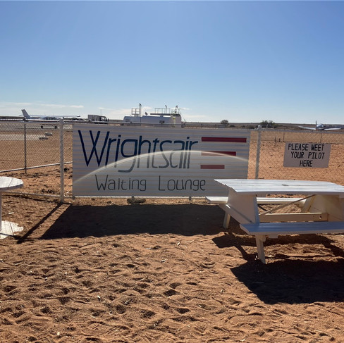
Having been told that the first 60km had the worst of the dreaded corrugations and the rest was "...like driving on the highway...", the first leg to William Creek was more like 150km of b..stard, bone-shaking corrugations and may be 50km of dirt roads where I was able to maintain a comfortable 75-80km/hr riding on top of the corrugations....it wasn't to improve much over the subsequent 400km either! I arrived on a Saturday and booked a flight over Lake Eyre for the following Tuesday morning. With absolutely nothing at William Creek other than the expensive pub (while the goat curry was delicious, a single can of alcoholic lemonade was A$15!) and airfield, I took a side trip to Coober Pedy on the Sunday to experience a night sleeping in an underground motel room.


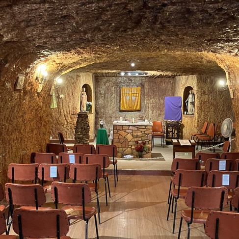
Coober Pedy / selfie with snailspace / underground motel room, Coober Pedy / Catholic Church, Coober Pedy
Yet another bone-shaking 160km dirt road before arriving at Coober Pedy, which has to be one of the wierdest places around - mostly an expanse of dusty desert covered in thousands of mullock heaps created by digging for opals over a period of 100 years or so! Being a Sunday and experiencing the start of the hot weather, there was very little going on in this town, but I did enjoy a commendable seafood laksa soup that evening from a restaurant perched on one of the few real hillsides in town. My underground accommodation was pretty spartan and probably only a couple of metres below the surface it had been dug into, but the temperature does stay at around 21-23 degrees C (obviously it is cooler the deeper you are underground), which makes it more amenable for both the extremes of winter and summer. My motel was next door to the catholic church, which was quite a unique little spot.
Despite Coober Pedy being the world's largest source of opals, I did not purchase any ('solid' opals started in the low hundreds and, while doublet opals (a 'slice' of opal bonded to a dark backing of ironstone or obsidian) and triplet opals (an even thinner slice of opal that is both bonded to a dark backing and then protected by a crystal dome) were considerably cheaper), other than a miniature jar of opal 'bits'/off-cuts to remember Coober Pedy by!


Airfield waiting room, William Creek / selfie with aircraft / Lake Eyre scenes
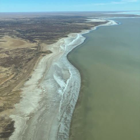
Back to William Creek the next day... on the same diabolical dirt road... Because of the increasingly hot daytime temperatures, the flight departure for my flight over Lake Eyre was brought forward from 0930 to 0800. The aircraft was a 14-seater and quite comfortable (especially compared to the 4-seater I had flown in over Carnarvon Gorge in QLD the previous year!) with noise-cancelling headphones provided so you could actually follow the pilot's commentary, even if a bit hard of hearing, like me. Pictures and videos from the aircraft cannot do justice to the amazing and expansive vistas of Lake Eyre in full flood (the lake had actually started to recede, as evaporation now exceeded the water still flowing into it by the time I flew over, but the lake still covered an area the size of Wales and having filled up from the rivers and trubutaries coming down from Queensland several months after the severe flooding experienced in those places. This was the most extensive flooding/filling of Lake Eyre for more than fifteen years, so I was quite privileged in what I was able to see. The fact that fauna/fish are able to survive in this lake despite the incredible salinity (with some creatures even able to 'hibernate' beneath the dried out lake until a suitable flooding re-awakens them) is really remarkable. Once Lake Eyre has dried out/receded, it leaves behind some 400,000,000 tonnes of salt!


snailspace on the Oodnadatta Track / Pink Roadhouse, Oodnadatta
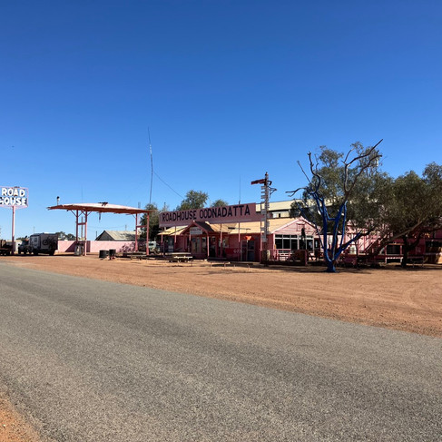
After the flight I tackled the second 'third' of the Track to the township of Oodnadatta. The road was bloody awful for the most part, but when you did strike a comparatively smooth stretch of dirt road or hit the right harmonic speed to 'glide' over the top of the corrugations, you were almost pathetically grateful!! Oodnadatta is well-known for its pink roadhouse, which is the only substantial structure there. Like most remote places, you pay for the privilege of a campsite (particulary with power so you can run your air-conditioning with impunity) and the price of both fuel and commodities reflect both the distance and diffculty of their delivery! The final run to Marla was pretty much a repeat - heaps of horrible corrugations, terribly stony tracks, dusty washouts and deceptive dips in the road that really tested your suspension. One set of corrugations that I struck was so severe that the vehicle's instruments assumed I had had a collision and started the emergency remote recording feature...apart from alot of swearing by me, there was no follow-up by Toyota after the recording stopped!
Maree was a welcome bit of civilisation with bitumen roads and a swimming pool at the hotel/campground. Apart from some of the food stored in cupboards having shaken itself to powder (...and discovering that an opened cardboard milk carton does not contain its product with the lid merely pushed close in the fridge), the moho survived the roads remarkably well. As I was to discover later in Port Augusta, the only item that I lost/fell off was the plastic centre wheel hub cap on one of my alloy wheels - which I hope to replace during the Christmas break.
Following the advice by the Birdsville Hotel Recovery Service that they would not cover my motorhome for the trip across the Simpson Desert (it exceeded their height margin by a mere 100mm!) due the lateness of the season and the daytime heat also causing the sand to become very soft (and potentially causing their recovery vehicle with my moho on their tray to topple if they were to hit a soft patch), and with the rising daytime temperatures getting up to the early 40's, I determined that I would tackle the Simpson Desert track next year...in the winter. I had also had enough of rough dirt roads for a bit, to be honest. So I turned south (summer temps heading north were getting silly - even the Laksa festival in Darwin failed to tempt me further northward!), stopping again in Coober Pedy (above ground campsite this time), Glendambo (middle of nowhere) and then Port Augusta. It was here that I washed all the orange bulldust and dirt off and noticed the wheel centre cap was missing.


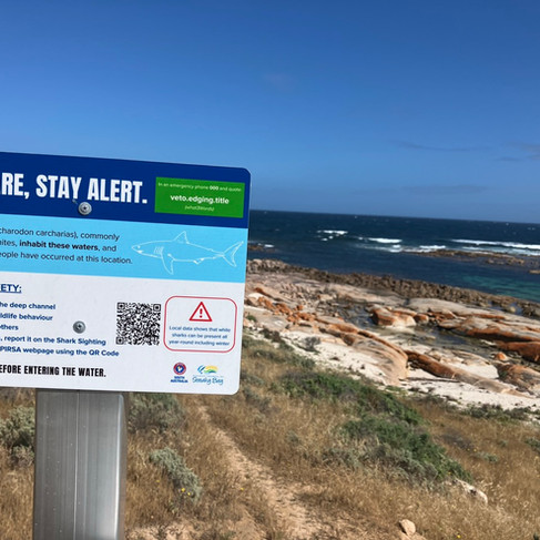
Lake Hart, Wirraminna / Wudinna / Smoky Bay foreshore
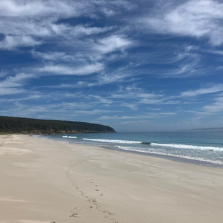
As an alternative to the Simpson Desert crossing, I decided instead to 'coddiwomple' around South Australia and its peninsulas a bit more thoroughly (I had crossed the top of the Eyre Peninsula rather hastily the previous November on my way back to Raymond Island from WA) so, after Port Augusta, my first stop was Wudinna, a small town in the wheat-growing region of the peninsula, where I stayed at the local showgrounds and a very well maintained and featured RV park. From here I headed to Smoky Bay on the northwest side of the Eyre Peninsula, however, the beachfront / oyster-farming area was beset by atrocious weather (gale-force winds, rain, electrical and thunder storms), so I had to content myself with another 'dhobey' run. While the next day was still very windy (but much drier), I took the opportunity to visit one of the local oyster farms' outlets (there were around 14 of them in the area of Smoky Bay alone!) and sampled half a dozen enormous, plump and juicy oysters with a home-made chilli vinaigrette that were absolutely outstanding (and great value at $12, as in pubs and restaurants they generally start at @$23 to $25 a half-dozen)... I also took another 6 oysters kilpatrick in a vacuum pack for grilling that evening as an entree! As the morning of my departure was a glorious and sunny one, I grabbed a picture of 'snailspace' on the foreshore and took the opportunity to walk along the beach, before heading to my next stop, Streaky Bay (only an hour down the road).


Mackie's Bridge / The Granites / Venus Bay Lookout / Venus Bay scultpures
The gloriously hot weather continued here, too - so much so that I booked an extra night, as my site was right opposite a great beach. I walked the beach and swam here - even having to seek the shade later in the afternoon because of the heat! Unfortunately, that night the wind, rain, lightning and thunderstorms resumed in earnest and, with the exception of some brief intermissions where it was just the gale force (and cold!) winds - it remained this way for much of my time in South Australia.
From Streaky Bay, I took a scenic loop drive on dirt roads (rough in places!) called the Westall Way, including stops at Mackie's natural bridge, The Granites, Smooth Pool and the Yanerbie Sandhills as I headed to my next stop at Venus Bay (and more oysters!).


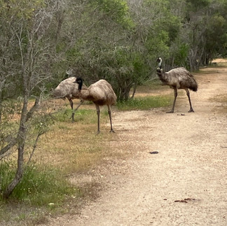

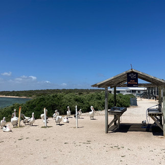
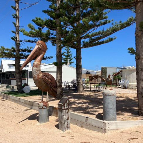
Yanerbie sandhills / wandering emus, Venus Bay / Patient pelicans waiting for the fishermen, Venus Bay


Ellliston sculpture trail / selfie with giant jandals / Greenly Pool
After Venus Bay, my next stop was Elliston and its sculpture trail, followed by checking out Greenly Pool - a well-sheltered and safe tidal pool. Although there was a family there swimming, both the cold wind and the walk back to where I had parked 'snailspace' conspired to persuade me not to take a dip!


Coffin Bay Jetty / Coffin Bay oyster farm
My next destination was Coffin Bay for a few days - only one of which was warm and sunny! Fortunately for me, this was the same day I had booked a boat tour of one of the oyster farms. It was a worthwhile tour to learn about the different methods of farming oysters between NZ and SA - for example, in Coffin Bay the oysters are regularly exposed to the sun and air in between tides (as opposed to remaining permanently submerged) which conditions them to be able to tolerate periods out of the water and stay fresher for longer - particularly for local delivery journeys and an extended shelf life once harvested. The tour included learning how to shuck oysters and eating a bunch of them, too (and I am really starting to develop a taste for them!).


Redcliff Beach / Port Elliot / Tumby Bay mosaic and street art examples
From Coffin Bay I meandered through the southernmost tip of the Eyre Peninsula, stopping at a largely deserted Fishery Bay Beach, Port Lincoln (where the weather was so inclement I barely left my moho for two days!) and Redcliff Beach. I then took a 'dhobey run' break in Tumby Bay, which, despite being a small town, has made a distinct effort to attract tourists with its many examples of impressive street art.


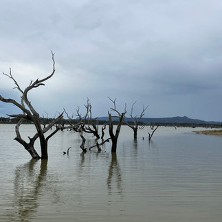
Port Neil RV Park / Yeldulknie Weir
As I travelled north on the eastern side of the Eyre Peninsula, I stopped overnight in Port Neill, another small town where I had probably my warmest welcome in the pub by both the publican and his wife (who provided free snacks with your drinks and a post-prandial chocolate after dinner - very civilised!) and the locals, who were happy to chat to visitors. I also spent a night in a free camp at a place called Yeldulknie Weir, slightly inland from the coast. A testament to the very dry conditions experienced on the peninsula was that the weir had very little water (see above), despite having overflowed earlier in the year.


Whyalla circular jetty / Whyalla steel works / federation-style heritage building example
At the top end of the Eyre Peninsula on the eastern side is the town of Whyalla, where I spent a couple of nights in a caravan park. From one of the principal lookouts in the middle of town you could look to the right and see their famous circular wharf (however impractical it might actually be, it is unique!) and in the other direction, the not-quite-so-attractive, "dark, (and) satanic" steel mill (which has featured in news in 2025 as it has struggled financially and required government intervention/support to keep it operating).


Corny Point Lighthouse / snailspace @ Troubridge Lighthouse / Stenhouse Bay Wharf / Edithburgh
After the Eyre Peninsula, I briefly meandered through the Yorke Peninsula, stopping or passing through Kadina, Moonta Bay, Port Victoria and Corny Point on the West side followed by Stenhouse Bay (the picture above taken from the heritage-listed wharf, from where Australia's primary source of gypsum (used for plaster and in cement) was mined and despatched), Troubridge Lighthouse (uniquely shaped and built in brick in 1980) and Edithburgh on the East side.


Port Julia Jetty / Port Wakefield / Port Adelaide beachfront (Semaphore Park) / Cape Jervis
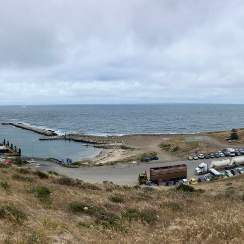
I passed through Port Julia as I continued up the eastern side of Yorke Peninsula. It was a tiny settlement that had once been a thriving agricultural port at the turn of the 19C (the red-roofed building at the end of the jetty was built in the 1920's and was the focal point for both storage/trade and local social activities), but was now more of a holiday destination and fishing spot. I had then planned on a night's Free Camping in Ardrossan, however, on my arrival I discovered there were only three sites...and all of them occupied. Fortunately, as it was still low/off season, I was able to find a site in Port Wakefield at the very top of the peninsula. From there, it was a couple of nights at the Port Adelaide beachfront (being close to Adelaide, the cost of campsites rises significantly!) in an interesting place called Sempahore Park, including a working semaphore ball tower. It was only a short drive down the Fleurieu Peninsula to Cape Jervis, which is little more than a ferry terminal servicing Kangaroo Island (KI).


KI local resident / Penneshaw Sculptures / Penneshaw foreshore - rock carving by French expedition from 1803
The ferry prices for the 45-minute trip were pretty steep - almost $500 return, and they charged a separate fee for the driver (though I'm not sure how they get the vehicles on and off without one!). While I acknowledge that Kangaroo Island had been ravaged by bushfires in recent years and is slowly regaining its desirability as a tourist destination, prohibitively expensive ferry rides are hardly likely to do much to encourage people to drive there for a holiday! The ferry from Cape Jervis on the mainland delivers passengers to Penneshaw on KI, which boasts only one caravan park (and the priciest laundromat so far on my 'Big Lap'!), but possessed redeeming features, including a great pub, cafes and a supermarket, with plenty of interesting attractions within walking distance.


Prospect Hill Lookout over Pelican Bay, KI / Pennington Bay , KI / American River , KI
From Penneshaw I headed in a generally westward direction, stopping in at Baudin Beach before tackling the several hundred steps up Prospect Hill to a lookout with impressive views over Pelican Cove and the island in general. I then dropped down to Pennington Bay on the southern coast, however, the blustery, grey and cold weather precluded anything more than a quick look!
Apart from the Caravan Park at Penneshaw, most of my stops in KI were at council-run campgrounds which had to be booked online. While they were well-situated and had the basics of designated sites / toilets, they came at a cost of $23 per night. As there were no established free camps on the island, this proved the most reliable solution during my time there. The first of these was at American River, where I again sampled oysters - not as good as Bruny Island or the Eyre Peninsula, but very enjoyable, nonetheless!
Dolphins at Emu Bay, KI


Continuing westwards, the next stop was at Emu River and a beautiful, deserted beach walk, complete with the company of dolphins. Amazingly, the wind dropped and the sun came out - albeit briefly! From there I stopped overnight at Western River Cove. Again, a lovely beach/river mouth off the beaten track. I managed a refreshing swim in a sheltered rock pool, but the wind made it feel alot cooler than I would have liked.
Western River Cove beach, KI


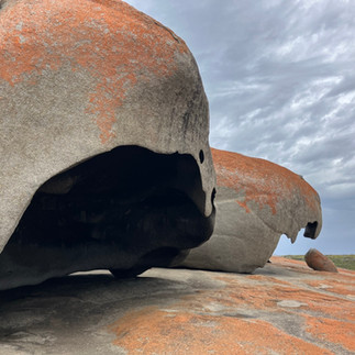


Cape de Couedic Lighthouse , KI / Admiral's Arch, KI / Remarkable Rocks , KI
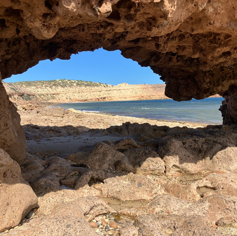
From Western River Cove I travelled to the Flinders Chase National Park in the southwest of the island. I spent the morning exploring the Cape de Couedic Lighthouse, Admiral's Arch and the Remarkable Rocks (the selfie above was of me inside the rock on the picture to the left of it!). These formations were the result of erosive wave (when the sea level was higher), wind and spray, and the heating/cooling/wetting/drying action (over some 200million years) on the granite dome.


Raptor Domain, Kangaroo Island
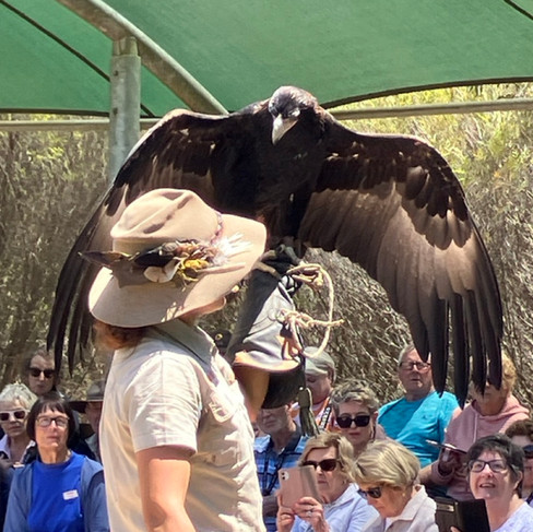
Following a night at Vivonne Bay, I stopped in at the Raptor Domain, which was a better experience than I had anticipated. I enjoyed both the interaction with the birds of prey and the very informative commentary by the bird handlers. I had a large owl (bottom right pic) sit on my knee and stroke its back/wing feathers, which were remarkably soft - apparently a characteristic which makes them almost silent in flight and very effective hunters of mice!


Chapman River, KI / Antechamber Beach, KI
I subsequently spent my penultimate night on Kangaroo Island at Brown Beach, having booked on my arrival on the island a degustation menu experience at Sunset Food and Wine nearby. I'm not sure how it all went pear-shaped, however, the place was locked up/closed and subsquent calls to the telephone number used to make the booking went unanswered - a bit disappointed, therefore, to return to my campground and have a tuna salad instead! My final day was spent visiting the Chapman River and Antechamber Beach. The day was noteworthy, as it was a day of blue skies, blazing hot sunshine and 33 deg C. I enjoyed a swim at the deserted beach (having encountered only one local walking her dog) and felt that this is what the weather should have been like for the previous week! To make up for the previous night's dining disappointment, having parked up at the Caravan Park, I had a slap-up meal at the Penneshaw Pub (notwithstanding that the mussels had me up later that night...all night...!!), before departing Kangaroo Island early the next morning.


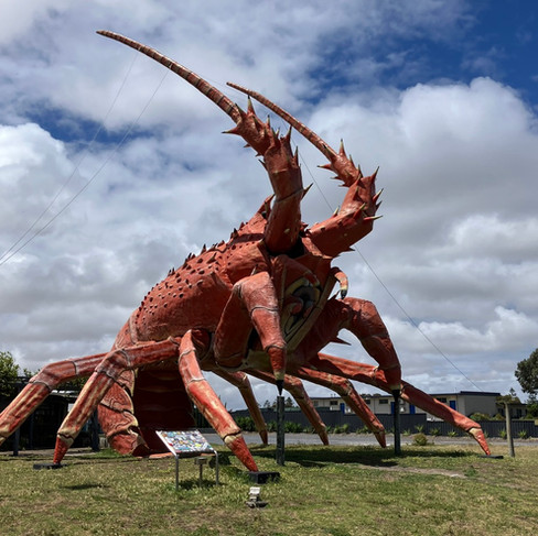


Granite Island Reserve , Victor Harbour / Wellington Ferry / Larry the Lobster, Kingston SE / Kingston SE
From Cape Jervis, I continued up the eastern side of the Fleurieu Peninsula to spend a few nights at Victor Harbour. Keeping to the coast, I continued southward to Kingston SE (Kingston South East - to distinguish it from Kingston on the Murray River), most notable for Larry the Lobster, which, at 15m high, is one of the largest 'Big Things' (quirky sculptures) in Oz. My stay here was yet again characterised by more wind, lashing rain, with only the briefest of patches of sunshine.


Carpenter Rocks, SA / Little Blue Lake, SA / Mount Schank, SA
My final night in SA was at a windy Carpenter Rocks, where I managed a walk along the beach in the sunshine....before the rain set in once again. Now back in Victoria once again, I decided to travel inland, having previously 'done' the Great Ocean Road around the coast to Geelong. I stopped overnight at Warnambool (windy), Lake Bolac (hot and sunny....and windy) and the Lake Colac beachside Free Camp. The latter was well-maintained by the local council and surprisingly popular/busy. It was a shame, however, that there was alot of plastic rubbish and broken glass around. Apparently, if the weather is good, the lakeside attracts the local bogans to congregate here and indulge in loud music, bright lights and lighting fires.....thankfully it was too wet and windy the night I was there, but I still managed to park up next door to the inly RV set-up that decide to flash up its noisy generator as the sun went down! I stayed a couple of nights in Geelong, catching up with Emma Gill and family (her husband, Karl, was unfortunately working in Townsville at the time).


Tidal River Reserve, Wilson's Promontory, VIC
Instead of driving through Melbourne to head back to East Gippsland, I instead took the ferry from Queenscliff to Sorrento (it was well worth the $108 (for both the vehicle and driver for 40-minute ferry journey.....refer previous comments re: the Kangaroo Island ferry!). Following an overnight stop at Poowong Recreation Reserve, I headed to Wilson's Promontory and the last vehicle camping spot at the Tidal River Reserve. Having checked out the extensive camping area on my Wikicamps Australia app, I assumed that, with well over 100 sites, I would have no problem getting a site - particularly as it was still shoulder (as opposed to holiday/silly) season. How wrong I was - I fronted up late in the morningonly to discover that it was almost completely booked out, with the exception of a few sites close to the visitor centre. The comprehensive campgrounds were the result of the Tidal River area having been used as a WW2 training ground for Australian and NZ commandos, due to both its remoteness and the varieties of terrain and environments it could offer in one location.


Buchan Caves, VIC
From Wilson's 'Prom' I headed back towards East Gippsland and Raymond Island, stopping at Golden Beach, followed by Buchan Caves (as the site had been closed on my arrival in Victoria with severe flooding and two deaths, and remained closed for many months thereafter). Finally some hot weather! While the cave systems were extensive, I felt that the formations were less impressive than previously-reported grottos, but the tour was abbreviated due to the previous flooding damage. While in Buchan I stayed at a Free Camping area near the Recreation Reserve and beside the Buchan River. Despite its size (I estimate that there was easily space for @80 RV set-ups), lush, level grass sites and proximity to 'town' and the caves via a convenient swing bridge across the river, I was the only person there for the first night! Following a discussion with some fellow travellers from the UK that I met while swimming in a pool that was fed by the underground cave river systems (...and accordingly which was VERY refreshing!), they joined me that evening in their 4WD with a roof-top-tent.


Lakes Entrance, VIC / Raymond Island, VIC
I stopped the next day in Lakes Entrance to replenish with a few fresh essentials from the supermarket. I took the opportunity to check the availability of sites at one of the many foreshore campgrounds (expecting there to be restricted availability due to school holidays having started for most and also being a weekend) in this very tourist-oriented township and was so surprised to find a waterfront site with power and fresh water was available for $35 per night for the next few nights, that I snapped it up for a bit of a pre-Christmas chill-out. It was lovely that first hot afternoon having put the awning and table out, to be able to take a dip right behind my site (despite the water being a bit shallow and weedy). The lovely weather, however, did not last and, within a few short hours, the storm clouds and strong winds rolled in. 50km/h winds with 70km/h gusts the following day put a dampener on things and made it impossible to put the awning up or even sit outside! Following a final dhobey run and moho clean for the year, I then spent a couple of days in Bairnsdale where I had a service by the local Toyota dealer on my Hilux. It was then back to Raymond Island and the sanctuary provided by Henri and Kate for the Christmas holiday period...even with a bit of a wet start!
In general the weather over the past few months of travel (mainly in South Australia, but also Victoria) has been consistently bad, characterised by a predominantly cold SW wind and plenty of thunderstorms, lightning and rain, especially in SA. Despite warm-ish sea water temperatures, there have been only a few (may be 6) days where it was sufficiently hot to swim at some of the beaches along a spectacular coastline. I have been told that such volatility in the weather is common in springtime - something certainly being borne out by the frequency of heatwaves in these regions being experienced at the time of writing!
I had hoped to publish this latest blog before Christmas, however, a last-minute trip back to NZ to celebrate my mother's 94th birthday at the end of 2025/early 2026, combined with my general indolence in retirement, has resulted in a much-delayed listing - which I do sincerely regret! Hopefully, travels will resume in mid-February as I aim to cover NW West Australia, Darwin and the top end of Cape York (finally), before a last motorhome service in Brisbane, crossing the Simpson Desert and preparing the motorhome for shipping back to NZ around September.
So until the next instalment, dear family and friends: hasta pronto, au revoir and hooroo!
Jimmo (James)
+61 400 068 257


Comments